Master Street Plan#
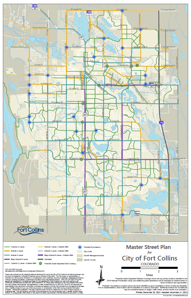
Download the 2023 Master Street Plan map here:#
You can also view the map online at FC Maps
What Is The Master Street Plan?#
The Master Street Plan (MSP) is a map of the City's long-range vision for its major street network. This includes existing and future vehicle, bicycle, and pedestrian connections throughout the city and its growth management area
The MSP also reflects the type of street (i.e. collector, arterial, etc.) and the general location for planning transportation connections. Final street alignments are determined and designed at the time of development.
Not all city streets are reflected on the MSP. The map depicts only shows arterial and key collector streets. Other collectors and local streets are not represented on the MSP but can be found on approved development plans and subdivision plats.
How Is The Master Street Plan used?#
There are a variety of ways that City staff and others use the MSP.
Development Review: The City of Fort Collins Land Use Code requires that all development plans "provide for or accommodate the streets and transportation facilities identified on the MSP." This requirement allows the City to ensure that the necessary land and funding to construct the street are provided at the time of development. The City's Complete Streets policy ensures that bicycle lanes and sidewalks are part of newly constructed streets.
Development Impact Fees: The City Engineering department uses the MSP to determine development impact fees for streets (Street Oversizing Fees). These developer fees help pay the portion of street costs related to the traffic created by the development. The fees are revised on a regular basis depending on changes to the MSP.
Planning Transportation Connections: The MSP is an excellent tool to understand the City's long-term vision for our street network. Developers, residents, neighboring communities, and others can learn how the existing and future network will impact a development, safe routes to travel to school, or a connection to another municipality's transportation system.
2023 Update Overview#

The 2023 MSP updates include map amendments resulting from the adoption of the North College MAX Plan, several clean-up items identified during development review, and a developer-requested amendment associated with Montava. City Council unanimously adopted these changes on December 5, 2023. View the City Council agenda item (#8) HERE.
The North College MAX Plan, adopted by City Council in February 2023, supported the change to North Mason Street (no longer shown going through two mobile home parks) and Red Cedar Circle (terminating at Bristlecone Drive).
The Montava development-requested amendment changes the classification of North Timberline from 2-Lane Arterial to Collector within the proposed development which as not yet been constructed.
The clean-up amendments follow:
|
Street Name |
Former Classification |
New Classification |
|
East Laurel Street |
Collector |
Remove east of Stover |
|
Red Willow Drive |
Collector |
Add south of Linden Park |
|
East Vine Drive |
2-Lane Arterial |
Collector |
|
Hickory Street |
Collector |
Remove west of Soft Gold Park |
|
Brightwater Drive |
Collector |
Remove from Parkside Drive |
|
I-25 Frontage |
Collector |
Realign with bridge |
|
North Lemay Avenue |
4-Lane Arterial |
2-Lane Arterial |
|
Remington Street |
2-Lane Arterial |
Collector |
|
Timberline & Carpenter |
No Roundabout |
Add Roundabout |
How Is The Master Street Plan Updated?#
The MSP is a living plan and is regularly revisited and amended to reflect new infrastructure. An MSP amendment review incorporates a wide variety of information including technical analysis and input from various City departments, travel demand modeling, and City Plan and Transportation Master Plan policies. The data and City policies are compiled prior to formulating a staff recommendation to the City's Transportation Board, Planning & Zoning Board, and City Council.
Amendments to the Master Street Plan are reviewed by the Transportation Board and the Planning & Zoning Board for their comments and recommendations to City Council. City Council then decides by resolution whether or not to amend the Master Street Plan. The entire review process takes at least four months, including the preparation of staff reports.
For more information about the Master Street Plan, please contact us.