Mason Street Restriping Project
Project Overview
In Spring 2016, the City will restripe Mason Street, between Laurel Street and Cherry Street, to improve safety and operations for all users, including people driving, using transit, or bicycling. The new striping will provide dedicated bike lanes for the majority of the corridor in order to establish more intuitive, safe and predictable behavior for all users. We invite you to attend an upcoming open house to learn more about these safety improvements, and other bicycle-related projects.
Please join us:
FC Bikes Project Fair (including the Mason Street Restriping Project)
Wednesday, April 13
5:30 – 7:30 p.m.
Museum of Discovery
Project Background
The City receives frequent safety concerns regarding the current shared-lane (or "sharrow") conditions along Mason Street from MAX operators, bicyclists and drivers. In 2015, City staff worked to develop a design that would address these concerns, while implementing the recommendation from the City's 2014 Bicycle Master Plan. Mason Street serves as the Mason Trail extension, connecting people from the Mason Trail at Laurel to the Poudre River Trail at Cherry, and provides access to key destinations and businesses downtown. It is the City's goal to ensure this corridor functions safely for all users.
Project Goals
- Improve safety and comfort for all users traveling along Mason St.
- Provide consistent and dedicated bicycle facilities (5' min. bike lanes)
- Establish corridor striping that is intuitive to all roadway users
- Maintain convenient access to businesses
Project Design
The Mason Street Restriping Project will provide dedicated bike lanes or buffered bike lanes between Laurel Street and Cherry Street. Given intersection constraints, the right turn lanes will also function as through lanes for buses (as they do today) as well as for people on bikes.

On-street Parking Impacts
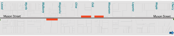
Given the curb-to-curb constraints, in order to provide consistent and dedicated bike facilities, on-street parking will be removed in the areas described below (and highlighted in red on the map). The City recognizes the loss of any parking is not ideal, and through this project we have worked to preserve as much on-street parking as possible, while still ensuring the primary goal of providing safe facility for all corridor users. As part of this project, the City will explore opportunities to add bicycling parking along the corridor to support additional access to Mason Street businesses.
Northbound:
- Mulberry to Magnolia (east side)
Southbound:
- Mountain to Oak (west side)
- Oak to Olive (west side)
Contact
Tessa Greegor | FC Bikes Program Manager | tgreegor@fcgov.com | 970-416-2471