Maxwell Trail Refresh#
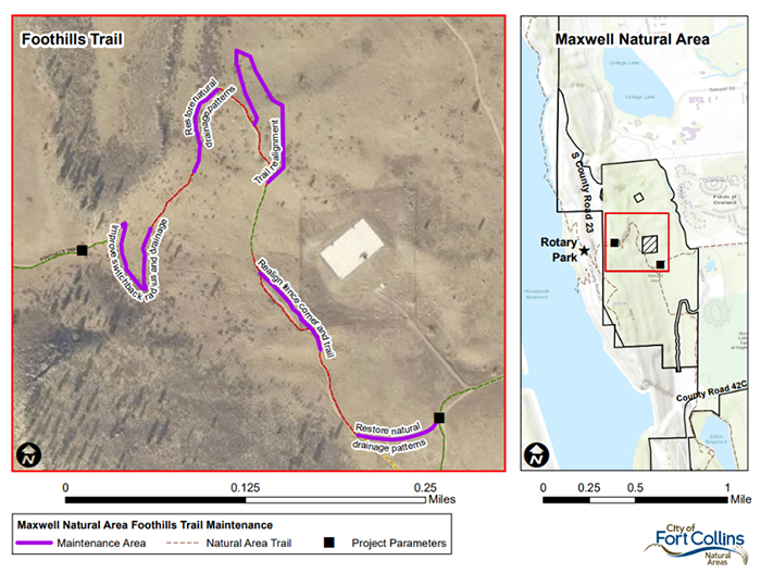
The areas in purple show sections of the trail undergoing maintenance.
The areas in purple show sections of the trail undergoing maintenance.
Maxwell Trail Refresh Project#
An extensive Foothills Management Plan engagement process was held in 2018 and 2019. Then in 2020, to gather additional feedback, the Fort Collins Natural Areas Department (NAD) held a forum with local stakeholders to specifically plan for the Maxwell Trail Refresh Project. Three main themes emerged: it is important to maintain safety, sustainability, and fun at Maxwell. The Natural Areas Department incorporated these three themes into trail improvements. There are five sections of trail that were improved are shown in the map above. The project details for each trail segment is as follows.
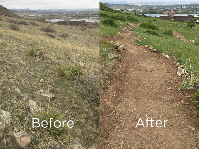
Section 1: The Bermuda Triangle#
- Trail improvement: Repair existing 200-foot section of “fall-line” trail by excavating, installing geocell fabric (or similar material), and backfilling to grade with amended tread material.
- Considerations: No new trail constructed, maintains efficiency for users, does not adequately address excessive speeds in the area (however the trail is wide enough for users to pass each other or step to the side), potential for continued erosion.
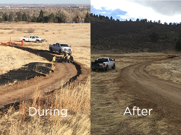
During and after installation of geocell fabric in the Bermuda Triangle section.
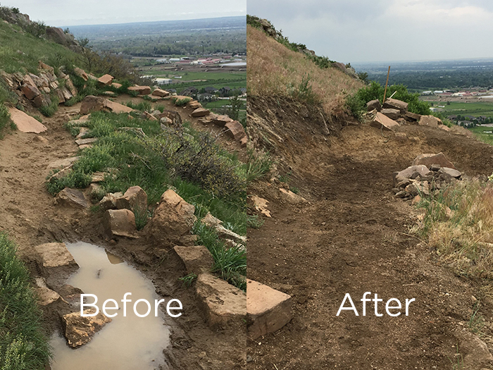
Section 2: Utilities Fence Corner#
This phase is still underway with completion expected by end of year.
- Trail improvement: Move fence corner to improve line of site and safety. Potentially realign 350 feet of trail to a more sustainable grade.
- Considerations: Improves line of sight, safety, and mitigates erosion and removes one of the trail’s technical experiences.
Section of improved trail near the utilities fence.
Section 3: The Calm Before the Storm#
- Trail improvement: Continued general maintenance on this section of trail with no improvements.
- Considerations: This is one of the most sustainable sections of trail at Maxwell, some discussion was raised during stakeholder events about it needing to be wider.
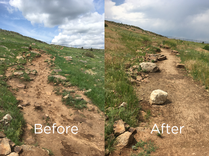
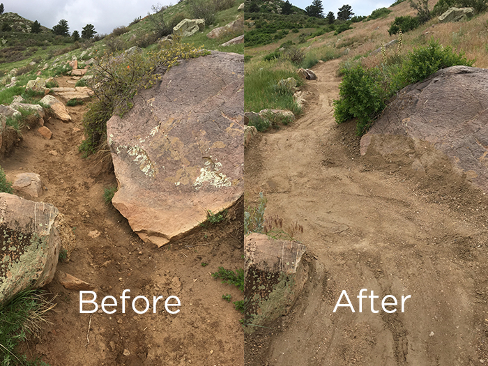
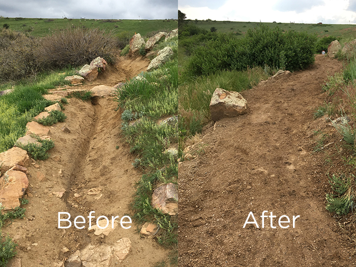
Section 4: The Channel#
- Trail improvement: Realigned 400 feet of this section of trail, east of the existing trail corridor. Closed the existing trail. Installed erosion barriers, native seed, fencing, and signage. For the remaining 600 feet of this section, installed large boulder checks at 20-foot intervals and filled eroded trail back to grade with imported soil transported by air lift.
- Considerations: Realignment will impact an estimated one acre of three leaf sumac plant community, there may be trail grade issues with realignment, concerns about losing imported soil via erosion, filling trail back to grade restores trail’s ability to sheet precipitation across its surface.
Before and after trail improvements in the Channel section.
Before and after the realignment of the trail in the Channel section.
Before and after trail improvements in the Channel section.
Before and after the realignment of the trail in the Channel section.
Section 5: The Switchbacks#
- Trail improvement: Extended switchback retaining structure 50 feet to the south. Filled switchback structure, improved turning radius, and repaired drainage capabilities of this section of trail with imported soil transported via air lift.
- Considerations: does not impact any plant communities.
Before and after the improved turning radius at the Switchback section.
Imported soil transported via air lift improved the drainage capabilities of this section above the switchbacks.
Before and after the improved turning radius at the Switchback section.
Imported soil transported via air lift improved the drainage capabilities of this section above the switchbacks.
Frequently Asked Questions#
What is the Foothills Trail and who uses it?
- The Foothills Trail through Maxwell Natural Area is a popular, multiuse trail that functions as a connector into two other natural areas and provides access to Horsetooth Reservoir. Hikers, bikers, equestrians, and birders use this trail system. Its total length is just over ten miles and reaches from Reservoir Ridge Natural Area to Spring Canyon Community Park.
Why was the trail restored?
Over the years, the Foothills Trail through Maxwell Natural Area has consistently degraded in condition. Several contributing factors include:
- Steep slopes
- Erosive soils
- North and east facing aspect (retains more moisture for longer periods, especially in winter months)
- Increased use and diversity of uses (originally designed for hikers not cyclists)
- More intense precipitation events in recent years
- Trail width in some places exceeded 20 feet wide and the depth in many places was nearly three feet below grade. The trail had become a dangerous and un-maintainable trench.
- Though maintenance was performed annually by the Natural Areas Department (NAD) staff and volunteers, the condition of the trail had degraded past the point where any meaningful impact or improvement could be made with hand tools or even small heavy equipment. The trail had simply suffered too much erosion through both use and weather and had lost its ability to sheet water.
How was the community consulted in this project and who was the decision-maker?
- Recognizing the challenges of the Maxwell trail as well as the community’s affinity for it, NAD began a several year-long conversation with trail users and stakeholders about how best to restore the trail to its original condition. Elements of this conversation included:
- Foothills Management Plan and public engagement process
- Informal conversations with users by NAD trail staff and rangers
- Ongoing meetings with Overland Mountain Bike Association and trail running groups
- Statistically valid survey research (2017-2018)
- Open Houses
- Focus groups/Forum with outside facilitator and trail designer
- Ultimately, this discussion led to a mutual understanding amongst various stakeholders that a compromise must be reached between visitor safety, trail sustainability, and recreational opportunity.
- Informed by these discussions, NAD staff developed the plan to best to repair the trail and implemented it.
What technical trail changes were made and how were best management practices integrated into this project?
- The trail was filled back to its original grade in order to achieve proper drainage and reduce water erosion.
- 250 tons were moved by helicopter in three days.
- To accomplish this with staff and or volunteers using bags or buckets would take an estimated 156 days or 39 weeks to complete.
- Explanation: If eight workers can make eight trips in a day from the top or bottom access points carrying 50 lbs. of soil on each trip they would move 3,200 pounds per day. 250 tons (or 500,000 lbs.) divided by 3,200 pounds per day equals just over 156 days or 39 weeks (4 day work week). This estimate does not factor in weather, injuries, and other unforeseen circumstances that would certainly prolong the duration.
- Specially blended soil that was added has already proven to be more durable and better draining than native soil after significant rainfall
- This is the same soil used to build Lory State Parks' bike “pump track”.
- The soil has enough clay content to bind, but also enough sand, silt, and rock to drain properly and provide durability.
- There are some areas on the trail where the tread has become loose. This is due to recent, dry atmospheric conditions, but the tread will tighten back up after some precipitation.
- Grade reversals were incorporated into the trail every 40 feet or as often as possible to help direct water off the trail.
- Grade reversals break watersheds (e.g.; the trail) into smaller watersheds that have less ability to develop momentum and scour the trail.
- This means less erosion and fewer muddy puddles.
- All the grade reversals built over a decade ago have now been restored to full function
- New grade reversals were built where previously there were none.
- Sinuosity was restored to the trail to add “fun” and reduce speeds.
- Achieved through choke points and closing braided and/or poorly functioning sections of the trail.
- Multiple “choke points” were constructed to help reduce user speeds and maintain trail sinuosity.
- Chokepoints are constructed out of boulders along the edge of the trail.
- They ensure that the flow of water and visitors undulates from one side of the trail to the other.
- This prevents both users and water from gaining too much momentum and damaging the trail through erosion.
- Banked turns were incorporated into the trail to aid users through turns.
- Trails staff rebuilt the switchback into a banked turn to improve rideability.
- New switchback sections also incorporate banked turns.
- Multiple “check ramps” were installed below the trail’s surface to help retain soil and prevent further erosion.
- This means that hundreds of more rocks were added to the trail then removed.
- All the old rocks are still there below the trail’s surface and form a skeleton that supports the newly created tread surface.
- The most unsustainable section of trail in the Channel area was realigned using the most recent trail design standards.
- Design Standards: grade reversals, choke points, trail grade is sustainably compatible with the slope of the hillside.
- The previous trail (e.g.; the Channel) went straight uphill and water could not exit it once on the trail. This is why it was three feet deep and three feet wide.
What resources were used to complete this project?
- With the goal of restoring the trail’s ability to naturally shed water, NAD contracted an air lift/helicopter service to move and place 290 tons of specially blended soil (designed for durability and better drainage than native soil) into the trench that had become the Foothills Trail. Due to accessibility issues, concerns over damaging the ecological integrity of the area, and a desire to complete the project as quickly as possible, the helicopter was the best option.
- The helicopter was in service for three days, and in that time a small crew of NAD trail staff were able to rebuild over 3000’ linear feet of trail that was eroded three feet deep and three feet wide.
- Additionally, volunteers from Colorado Addicted Trail Builders Society, Larimer County Youth Conservation Corps, and llama pack stock were utilized to help complete the project.
- An additional phase of this project will include realigning the trailside existing chain-link fence corner to improve the line of sight for trail users.
Contact
Ryan Kogut
Senior Supervisor
City of Fort Collins Natural Areas
rkogut@fcgov.com
970-416-2206