Natural Habitat Buffer Zone Reference Area Approach#
What is a Reference Area?#
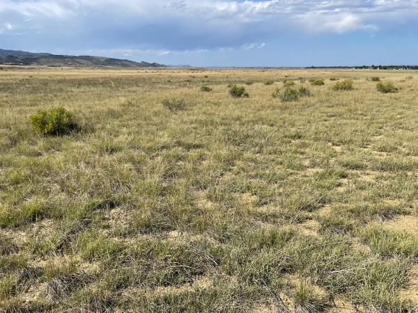
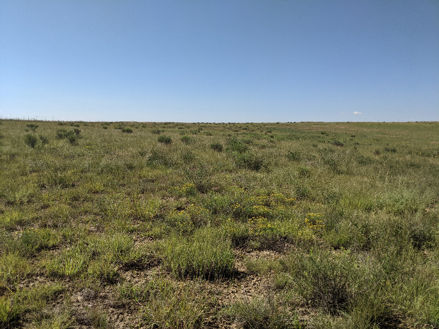
A mixed-grass community reference area at Coyote Ridge Natural Area. This reference area is a reclaimed wheat field and demonstrates achievable outcomes for native revegetation projects throughout the City.
A reference area is a community of organisms able to act as a model or benchmark for restoration. Reference areas are used to determine the percent cover success criteria for revegetation projects that contain Natural Habitat Buffer Zones and 1041 easements. They should be representative of the target vegetative condition, have similar management practices, and have analygous climatic conditions.
Reference areas currently utilized by the City include the following habitat types:
- Mixed-grass communities: an upland community dominated by native warm and cool season grasses
-
Mesic-grass communities: a community dominated by native warm and cool season grasses and forbs adapted to moist soil conditions
Why Use a Reference Area?#
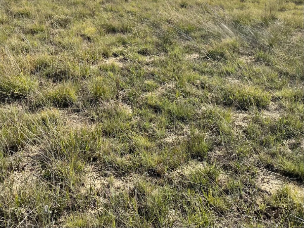
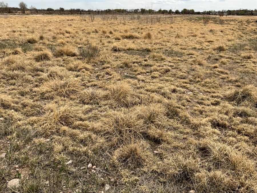
This image shows areas of bare ground between native grass species, which is typical in native mixed-grass communities. Monitored in 2024, the desirable vegetation cover for this area was approximately 49%, which accentuates issues with previous standards of 70% cover.
The overarching goal of using reference areas to determine vegetative cover success criteria is to create achievable and ecologically sustainable goals for revegetation projects within the City’s jurisdiction.
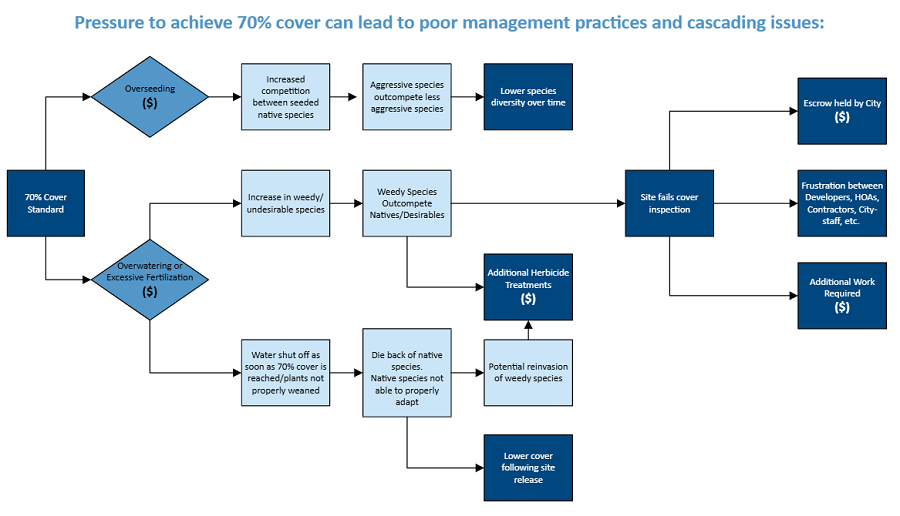
City of Fort Collins Environmental Planning previously adopted a revegetation success standard of 70% vegetative absolute cover which the vast majority of habitat types in the Front Range’s semi-arid ecosystems do not naturally support. The standard of 70% vegetative cover often puts developers, landscaping contractors, and City staff in difficult situations. Pressure to reach this standard of 70% vegetative cover in a relatively short time frame can lead to management practices that have cascading negative impacts, including:
- Heavy seeding rates
- Can result in unsustainably high vegetation cover to reach 70% criteria metric, that dies back to a sustainable level over the long term.
- Increased competition between species and lower species diversity over time.
- Overwatering or excessive fertilization
- Encourages growth of weedy species that outcompete desirable species or do not allow for initial native species establishment.
- Can lead to:
- Weedy sites, increased costs for additional weed management, and reseeding efforts.
- Excessive water use and associated costs.
- Low survival of native species if irrigation is not properly weaned once sites' vegetative criteria for success is met.
The reference area approach is fundamentally based on local data, thus making it a realistic and sustainable standard, as well as reflective of what can be achieved after similar management with the local climatic and precipitation conditions.
Where is a Reference Area?#
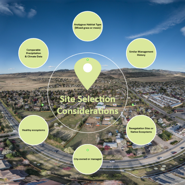
Graphic depicting considerations made during reference area site selection. Reference areas are selected annually as a collaborative effort between city staff.
City staff collaborate to select appropriate reference areas to use for a given year. Collaboration is between Environmental Planners, Natural Resource Inspectors, Botanists, and other City staff.
Reference area site selection is based on the following considerations:
- Analogous habitat type
- Comparable precipitation patterns and climate data
- Former revegetation sites or native ecosystems - sites include former mine sites, agricultural fields, or regional detention ponds.
- Similar management history - management typically includes an adaptive management approach. This includes a combination of herbicide applications, spot mowing of noxious weedy species, and periodic interseeding.
- City-owned properties
- In healthy condition
How are the Reference Areas Monitored?#
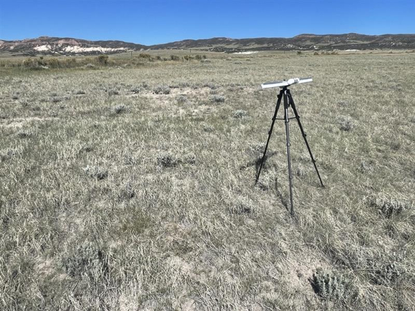
Cover monitoring equipment used by the City at a mixed-grass community reference area.
City staff sample the reference areas using a line point intercept method in a semi-random, representative manner that provides an ‘adequate sample’. i.e., an estimate of the sample mean is obtained that confidently estimates actual (population) mean, as demonstrated by Cochran’s formula for sample adequacy. Reference area sampling occurs at the peak of the growing season, (usually around late July-August) to allow warm season grasses and late blooming forbs to reach their peak growth. In a given year, 2-3 reference areas per habitat type (mixed-grass and mesic) are sampled. Percent desirable vegetation coverage is then determined for each community type for the given year, which becomes the coverage success criteria for revegetation projects at various City development sites. ‘Desirable Vegetation Coverage’ includes all species except for the following: introduced annual grasses, introduced annual forbs, state listed noxious weed species, and species defined as a “weed” in City Municipal Code section § 20-41. The results will be made available to the public annually for comparison to native revegetation projects at development sites with Natural Habitat Buffer Zones or 1041 easements.
Inspections for revegetation projects also occur annually by City staff in the same manner as the reference area approach, beginning 3 years after initial seeding of the approved seed mix. Once results are compiled and compared to the analogous habitat type, a report is sent to the developer and appropriate site contacts to communicate results for the given year. Sites must reach the coverage criteria determined by the reference area cover monitoring approach and additional criteria listed in the given site’s Development Agreement and Landscape Plan notes. Additional criteria typically include requirements regarding wetland establishment, percent weedy species, and bare ground areas, but varies site-to-site.
For instructions on how to perform cover monitoring using the line-point intercept method, review the Line-Point Intercept Cover Monitoring Guide.
Natural Habitat Buffer Zone Reference Area Sites#
-
Mixed Grass Reference Areas#
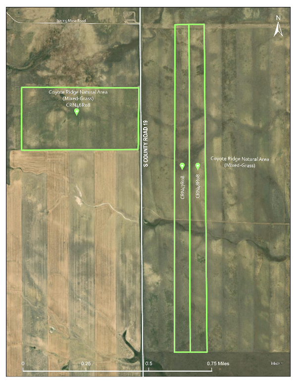
Coyote Ridge Natural Area#
![Map showing Coyote Ridge Natural Area]()
This reference area is a reclaimed wheat field. Restoration began with native seeding operations in 2008. The area was farmed previously, so the soil was tilled prior to purchasing the property and required no further soil prep. The area had little weedy species present. Following initial seeding, herbicide treatments and spot mowing occurred as needed for weed management. The current vegetation community is dominated by native grasses and forbs, with a few intermixed weedy species.
Habitat Type: Mixed-grass
Unit Identifier: Restoration Unit CRN48R08 (2024 monitoring); CRN47R08 (2023 monitoring)
Years used as reference area: 2023 & 2024
Desirable Veg. Cover (2023): 51%
Desirable Veg. Cover (2024): 49%
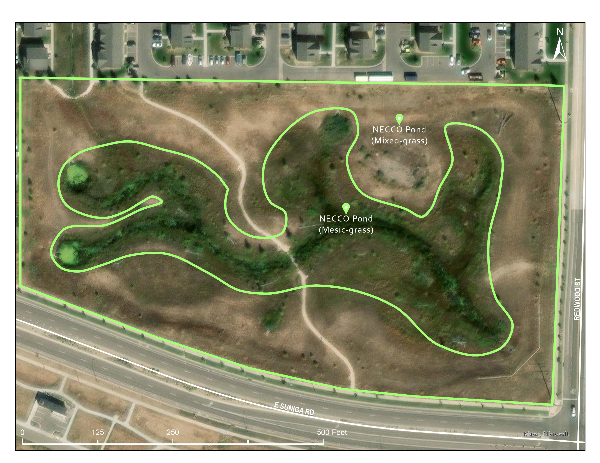
NECCO Pond- Constructed Detention Pond#
![Map of NECCO Pond area]()
This reference area is a City-owned constructed detention pond initially built for the Aspen Heights development project. Site ownership and management transitioned to the City of Fort Collins following completion. The area has both mixed-grass and mesic-grass community types. Being a constructed detention pond, the area represents achievable goals for other similar development projects.
Habitat Type: Mixed-grass
Unit Identifier: Parcel # 9701300908 (Detention on NW corner of E Suniga Rd. and Redwood St.)
Years used as reference area: 2024
Desirable Veg. Cover (2024): 57%
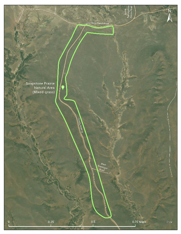
Soapstone Prairie Natural Area#
![Map of Soapstone Prairie Natural Area]()
The reference area at Soapstone is a partially restored, native mixed-grass community. Some areas of the reference area were disturbed during road construction and reseeded in 2008, however some areas remain untouched native grasslands. It is difficult to distinguish between the areas previously disturbed and native areas. Grazing occasionally occurs in the area. Native upland grasses, forbs, and subshrubs dominate the area, with few weedy species present.
Habitat Type: Mixed-grass
Unit Identifier: Restoration Unit SSN01R08
Years used as reference area: 2024
Desirable Veg. Cover (2024): 45%
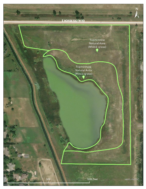
Topminnow Natural Area#
![Map of Topminnow Natural Area]()
Completed as part of the Rigden Reservoir construction, restoration began in 2015. New topsoil was brought in and seeded immediately to prevent initial establishment of weedy species. The area received good moisture in the first year seeded, leading to great initial establishment of native grasses and forbs. Weed management includes herbicide treatments and spot mowing, as needed.
Habitat Type: Mixed-grass
Unit Identifier: Restoration Unit TMN02R14
Years used as reference area: 2023
Desirable Veg. Cover (2024): 51%
Mesic-Grass Reference Areas#
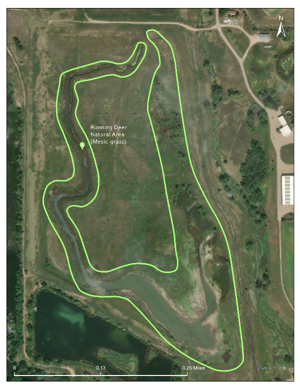
Running Deer Natural Area#
![Map of Running Deer Natural Area]()
Restoration for the mesic-grass community reference area at Running Deer Natural Area began in 2009 as part of a mine reclamation project. New topsoil was brought in and seeded by contractors. Weed management included a combination of herbicide treatments and mowing, as needed. The area currently consists of native grasses, sedges, rushes, and forbs with some weedy species.
Habitat Type: Mesic-grass
Unit Identifier: Restoration Unit RDN17R09
Years used as reference area: 2023, 2024
Desirable Veg. Cover (2024): 65% (2023), 58% (2024)
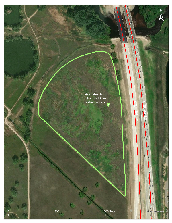
Arapahoe Bend Natural Area#
![Map of Arapahoe Bend Natural Area]()
The mesic-grass reference area at Arapahoe Bend Natural Area was previously an agricultural field dominated by smooth brome, cheatgrass, field bindweed, and Canada thistle. In 2004-2005, herbicide treatments targeted various weed species present. Roundup was used to treat smooth brome. In 2006, the area was seeded with a native mix. Weedy species, mainly cheatgrass and kochia, dominated the site for years and were treated with herbicides and mowed, as needed. Over time, the site became less and less weedy, transitioning to mostly natives by 2016. The site was reseeded periodically as needed, mowed occasionally, and herbicide treatments applied annually. The area currently has an abundant amount of native grass species with lower native forb counts.
Habitat Type: Mesic-grass
Unit Identifier: Restoration Unit ABN02R07
Years used as reference area: 2023
Desirable Veg. Cover: 68%
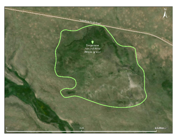
Soapstone Natural Area#
![Map of the mesic area at Soapstone Natural Area]()
A mesic-grass reference area at Soapstone Prairie Natural Area. The area is a naturally occurring mesic-grass community and consists mainly of native grasses, sedges, rushes, and forbs. There are few weedy species present and the site is in a fairly pristine condition.
Habitat Type: Mesic-grass
Unit Identifier: Management Unit SSN09 (native, not previously restored)
Years used as reference area: 2024
Desirable Veg. Cover: 79%
NECCO Pond#
![Map of NECCO Pond area]()
This reference area is a city-owned constructed detention pond initially built for the Aspen Heights development project. Site ownership and management transitioned to the City following completion. The area has both mixed-grass and mesic-grass community types. Being a constructed detention pond, the area represents achievable goals for other similar development projects.
Habitat Type: Mesic-grass
Unit Identifier: Unit Identifier: Parcel # 9701300908 (Detention on NW corner of E Suniga Rd. and Redwood St.)
Years used as reference area: 2024
Desirable Veg. Cover: 65%
-
Mixed-Grass Reference Areas#
Coyote Ridge Natural Area: mixed grass reference site
Soapstone Prairie Natural Area: mixed grass reference site
Topminnow Reference Area: mixed grass reference site
Running Deer Natural Area: mesic grass reference site
Coyote Ridge Natural Area: mixed grass reference site
Soapstone Prairie Natural Area: mixed grass reference site
Topminnow Reference Area: mixed grass reference site
Running Deer Natural Area: mesic grass reference site